

My second (or third, really) stint in college led me to the University of New Orleans to study for a Master’s Degree in Urban and Regional Planning. Since my focus was on transportation planning, I was tasked in one of my classes to pick a city anywhere outside the U.S. and write an essay detailing its transportation network. I had relatively recently visited Kyoto, Japan and was impressed with the passenger train system there, so picked that location to study further.
While this can be a dry topic for many, I did my best to insert some humor and first-person perspective in the piece in an effort to make it more readable. While I’m not sure how much my instructor appreciate these additions, I think it makes the paper much better. In this iteration, I’ve also added some pictures and graphics that hopefully make it an even better read. Enjoy!
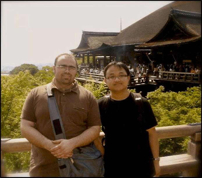
In the summer of 2007, some friends and I took a two-week trip to Kyoto, Japan. This was an incredible experience for me, a 24-year-old kid from po’Dunk, Louisiana who had never lived more than an hour and a half from home. A kid who, at the age of 16, was given a driver’s license, a 1985 Chevy Celebrity station wagon, and a gas card granting unlimited and unfettered access to Shell fuel. A kid who was given complete freedom of movement. Or, in planner terms, a kid who had access to all the mobility I desired.
And now, a kid who must negotiate his mobility in Kyoto, Japan – a city of approximately 1.5 million people (UNdata) – without access to a car, a limited ability to communicate, and a Shell gas card that impressed no one. Thankfully for this kid, he was in a city that anticipated and was built for such a situation.
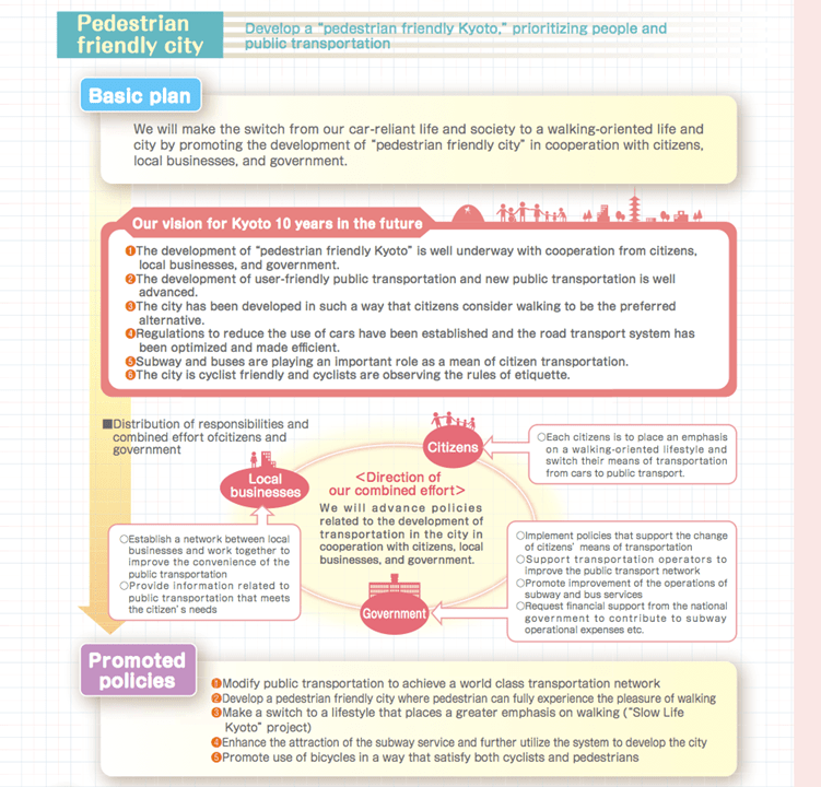
Kyoto, being the former capital of Japan and one of the nation’s oldest cities with a 1,300-year history, is viewed as the cultural center of the nation (Kyoto City, 8). It is both a domestic and international tourist destination (Ibid), and as such has been built to facilitate the movement of people to its many shrines, temples, and other cultural destinations via public transit. In fact, the city’s master plan calls for an even greater focus on walking and more investment in public transportation (Kyoto City, 36). Kyoto’s focus is to move its citizens away from a car-centric lifestyle to one in which cars are no longer a necessity (Ibid).
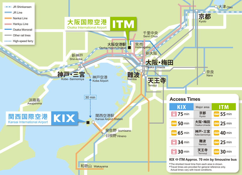
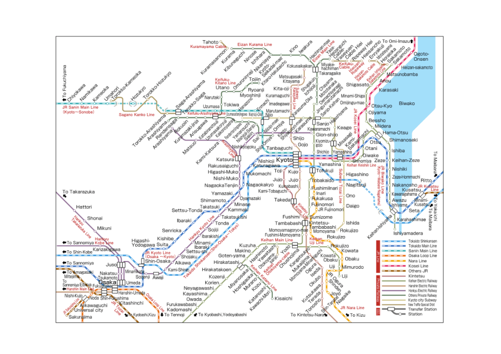
My journey started at the Kansai International Airport (as my Chevy did not have the ability to traverse the Pacific Ocean), located approximately 60 miles south of Kyoto. As one of Japan’s major international airports, Kansai is Kyoto’s link to the international community. It boasts 16,110,000 passengers a year and an annual cargo volume of 700,000 tons (New Kansai International Airport Company, Ltd). Kansai connects to Kyoto via the JR “Haruka” Limited Express located within the airport (Kyoto City Website). The Haruka line is a direct rail link between Kansai and Kyoto, with a travel time of 73 minutes. The line is one of several lines serving Kyoto and connecting it with the rest of the nation. Other long-range rail options are the JR “Nozomi” Shinkansen bullet train, which connects Kyoto to Tokyo and also to Hakata at 2 hours 22 minutes and 3 hours 5 minutes respectively (Kyoto City Website). In addition to long-range rail options, Kyoto is served by a subway system. The subway consists of two lines, the Karasuma line and the Tozai line, and 32 total stops. The Karasuma runs north to south and Tozai runs east to west. The two intersect and allow for transfer at the “Karasuma Oike“ Station (Kyoto City Website). The subway operates from 5:30 A.M. to 11:30 P.M. (Lonely Planet).
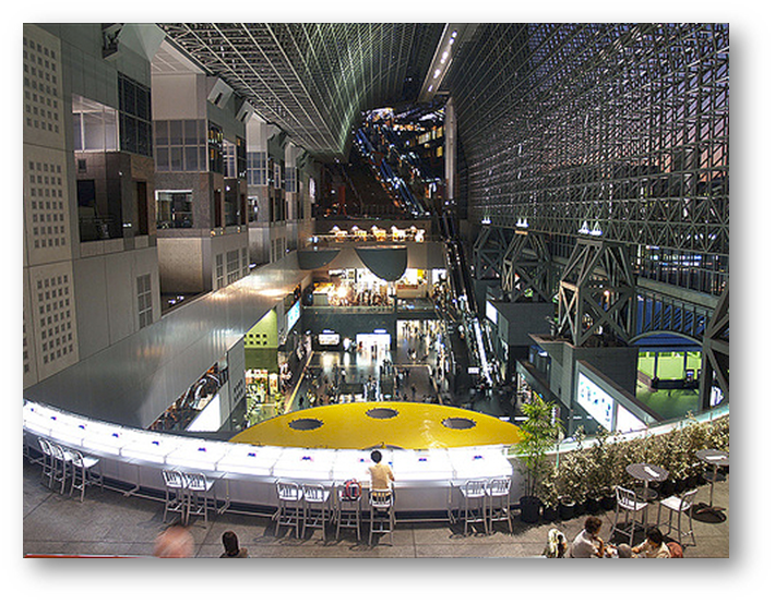
My ride on the Haruka Limited Express ended at Kyoto Station. Kyoto Station is the hub of all public transportation in Kyoto. It is, however, more than just a simple rail station. It is also a tourist destination with a movie theater, retail outlets, and restaurants (including Café Du Monde) located within the facility. The station was first opened in 1877 by decree of Emperor Meiji (Ishino) and is now one of the larger facilities in the city at 15 stories tall (Martin). In addition to providing connectivity between Kansai, Tokyo in the north, Hakata in the south, and two other major JR lines, the station also is located along the Karasuma subway line and provides connectivity to the city’s electric rail line as well (Kyoto Station Website).
As mentioned above, the city has an extensive electrified rail line in addition to the two main subway lines. While the two main subway lines run north-south and east-west, the electrified rail lines run all throughout the city on various links. Within the immediate vicinity of Kyoto station are no less than seven “private” rail lines (private meaning a non-JR rail) connecting dozens of stops (Kyoto Station Website).
Upon exiting the station, users are provided direct access to the city’s bus line. Bus terminals are located outside the northern entrance to Kyoto Station, where there are three departure bays (Lonely Planet). The numerous access points are designated by letter (bay) and number (the individual stand within each bay) (Ibid). Most helpful is the bus info center located in the terminal, where riders can purchase one-time tickets, ticket books, day passes, or two-day passes, as well as view maps of all routes and stops (Ibid). The information center also includes computer terminals that allow riders to select a destination and directs them to the correct bay and stand (Ibid). Navigating the bus along the routes is just as user-friendly as the terminal at Kyoto Station. Most bus stops display a map of the route, stops along the route, and a timetable approximating when buses would be at the stop (Ibid). The bus system also conveniently runs from 7:00 A.M. to 9:00 P.M., with some routes beginning earlier and running later (Ibid).
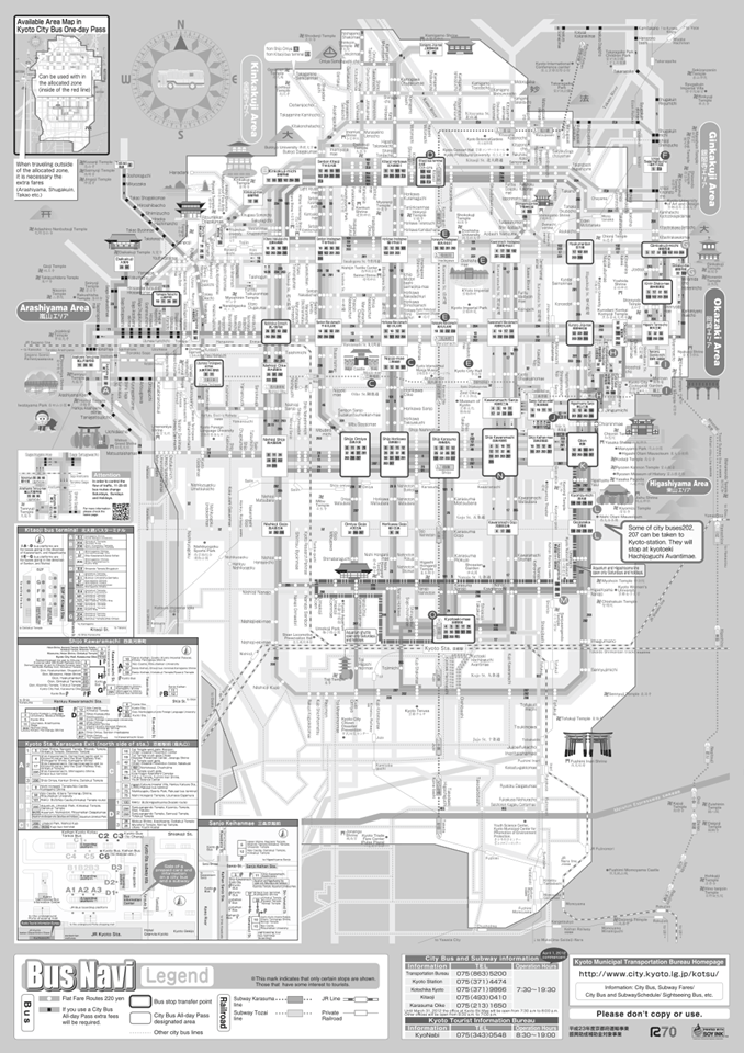
Despite the integration of these modes, the city seems conflicted over the use of bikes in the city. Lonely Planet describes the city as “a great place to explore by bicycle,” and the city’s master plan describes the city as “cyclist friendly” (Kyoto City, 36). Bicycling is featured on the online Kyoto Visitor’s Guide (http://www.kyotoguide.com) and bikes can be rented from the Kyoto Cycling Tour Project in several locations throughout the city, including a location near Kyoto Station (Touring Kyoto by Bicycle). Despite this promotion, however, the city maintains rules on when and where bicycles may be ridden. For example, bicycles are prohibited on certain streets downtown and must be pushed rather than ridden (Kyoto Visitor’s Guide). In addition, bikes parked on the street will also be impounded and riders must pay a fine to retrieve them. The city has designated bicycle parking lots, which charges users a fee to park. If I had to make a criticism on the transportation network in Japan, it would be this practice. However, it is difficult to tell, without knowing more of the history of transportation in the city of 1.5 million, if this criticism would be justified, or if this is a necessary policy due to the sheer number of cyclists the city boasts.
Future plans for the transportation network include the construction of a train that would connect Kyoto to the rest of the nation in an even more robust rail network. The nation is testing plans to implement a train that would travel 310 miles per hour, allowing riders to travel from Tokyo to Nagoya in 40 minutes. The line would cost $52 billion to construct and would require an underground tunnel 248 miles long, five times the length of the Chunnel in Europe (Cooper). The implementation of this new rail system would, in the future, create an even faster mode of transportation that the current bullet train provides. The current bullet train, as stated above, allows users to make the 320-mile trip from Kyoto to Tokyo in 2 hours 22 minutes. At 310 miles an hour, this new technology would cut that time in half.
My experience in this city changed the way I view transportation. While I still like my Chevy and Shell gas card, I saw a community where public transportation worked as an integrated and connected system. Up to this point, my experiences with public transportation in the U. S. led me to perceive it as used only by the poor and car-less segment of the population. Public transportation in Kyoto, however, seems to be a way of life for many of its citizens. In a city with a tremendous population yet limited space for infrastructure and growth, Kyoto stands out as a well-planned inspiration for public transportation.
Works Cited
Cooper, Chris and Kiyotaka Matsuda. “World’s Fastest Train Resumes Trials as Japan Plans New Line.” Bloomberg. 29 Aug 2013. Web. 17 Sep 2013, <http://www.skift.com/2013/08/29/worlds-fastest-train-to-resume-trials>
Ishino, Tetsu et al. (eds.) (1998). Teishajō Hensen Daijiten – Kokutetsu JR Hen (in Japanese). Tokyo: JTB Corporation. p. 34, vol. II. ISBN 4533029809.
Kyoto City. Miyako Plan – the Master Plan of Kyoto City, Digest Version. Kyoto: , 2011. Web. <http://www.city.kyoto.jp/>
“Kyoto City Website.” Access to Kyoto City. Kyoto City. Web. 13 Sep 2013. <http://www.city.kyoto.jp/koho/eng/access/access.html>.
“Kyoto Station Website.” Railway System. Kyoto Station Building Company, n.d. Web. 16 Sep 2013. <http://www.kyoto-station-building.co.jp/map_en/railway_system.pdf>.
“Kyoto Visitor’s Guide.” Web. 17 Sep 2013. <http://www.kyotoguide.com/ver2/thismonth/bicycle2010.html>.
“Lonely Planet.” Web. 17 Sep 2013. <http://www.lonelyplanet.com/japan/kansai/kyoto/transport/getting-around>.
Martin, Lisa. “Kyoto a Charming Place.” Daily Courier [Kelowna] 17 August 2013, Web. 17 Sep. 2013. <http://www.kelownadailycourier.ca/bliss/kyoto-a-charming-place-81813.html>.
“New Kansai International Airport Company, Ltd.” Company Profile. New Kansai International Airport Company, Ltd, Web. 16 Sep 2013. <http://www.nkiac.co.jp/en/company/outline.html>.
“Touring Kyoto by Bicycle.” Kyoto Cycling Tour Project. Web. 17 Sep 2013. <http://www.kctp.net>.
“UNdata.” United Nations Statistics Division, 05 Jul 2013. Web. 13 Sep 2013. <http://data.un.org>.
